


Center Twp. Voting District, Crow Wing County, Minnesota
About
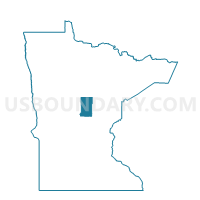
Outline

Summary
| Unique Area Identifier | 601657 |
| Name | Center Twp. Voting District |
| County | Crow Wing County |
| State | Minnesota |
| Area (square miles) | 21.70 |
| Land Area (square miles) | 17.83 |
| Water Area (square miles) | 3.86 |
| % of Land Area | 82.19 |
| % of Water Area | 17.81 |
| Latitude of the Internal Point | 46.49640150 |
| Longtitude of the Internal Point | -94.11248090 |
Maps


Graphs
Select a template below for downloading or customizing gragh for Center Twp. Voting District, Crow Wing County, Minnesota


Neighbors
Neighoring Voting District (by Name) Neighboring Voting District on the Map
- Blue Prec., Crow Wing County, MN
- Irondale Twp. Voting District, Crow Wing County, MN
- Lake Edward Twp. Voting District, Crow Wing County, MN
- Mission Twp. Voting District, Crow Wing County, MN
- Oak Lawn Twp. Voting District, Crow Wing County, MN
- Pelican Twp. Voting District, Crow Wing County, MN
- Wolford Twp. Voting District, Crow Wing County, MN
Top 10 Neighboring County Subdivision (by Population) Neighboring County Subdivision on the Map
- First Assessment UT, Crow Wing County, MN (5,424)
- Lake Edward township, Crow Wing County, MN (2,085)
- Oak Lawn township, Crow Wing County, MN (1,792)
- Irondale township, Crow Wing County, MN (1,134)
- Center township, Crow Wing County, MN (910)
- Mission township, Crow Wing County, MN (817)
- Pelican township, Crow Wing County, MN (446)
- Wolford township, Crow Wing County, MN (379)
Top 10 Neighboring Unified School District (by Population) Neighboring Unified School District on the Map
Top 10 Neighboring State Legislative District Lower Chamber (by Population) Neighboring State Legislative District Lower Chamber on the Map
Top 10 Neighboring State Legislative District Upper Chamber (by Population) Neighboring State Legislative District Upper Chamber on the Map
Top 10 Neighboring 111th Congressional District (by Population) Neighboring 111th Congressional District on the Map
Top 10 Neighboring Census Tract (by Population) Neighboring Census Tract on the Map
- Census Tract 9507, Crow Wing County, MN (5,797)
- Census Tract 9504, Crow Wing County, MN (5,233)
- Census Tract 9508, Crow Wing County, MN (4,666)
- Census Tract 9510, Crow Wing County, MN (4,124)
- Census Tract 9505.02, Crow Wing County, MN (2,567)